
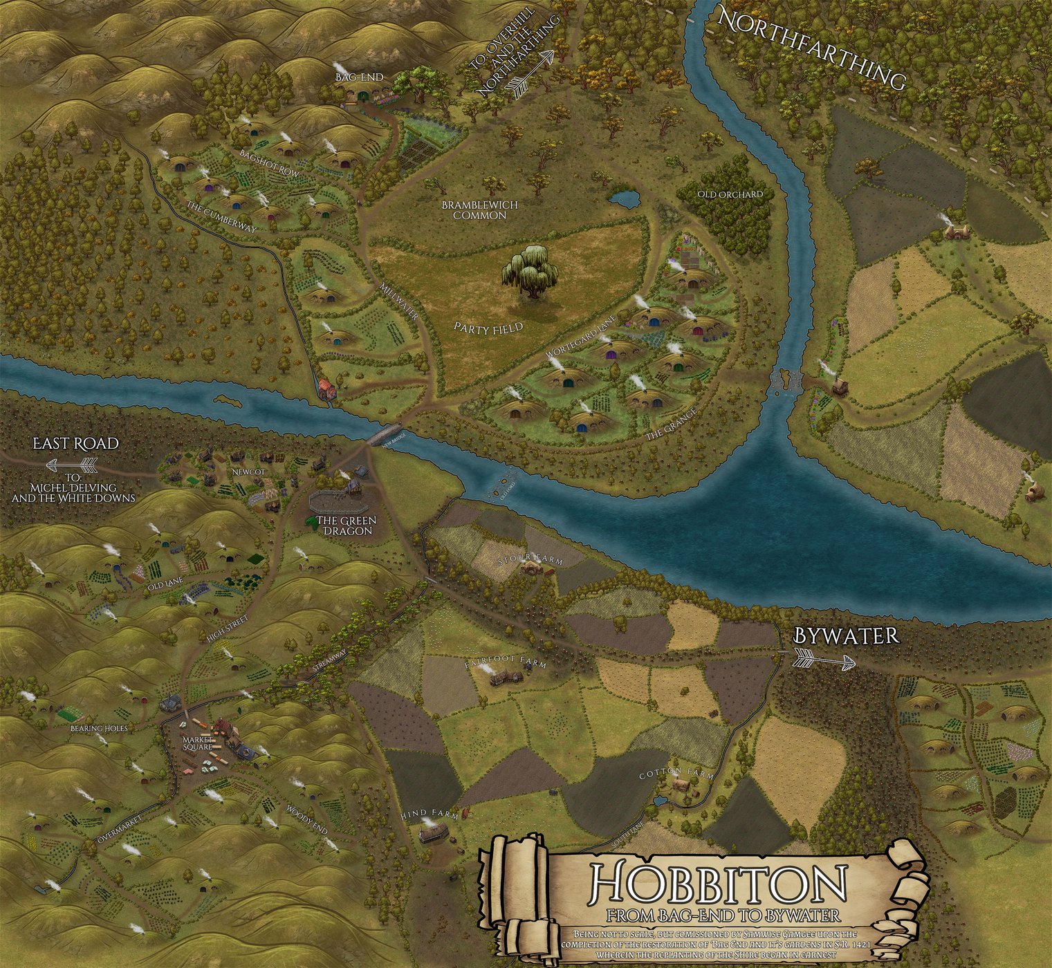
Not fully LOTR canon compliant, as it follows the canon of my own work where the sacking of the Shire proceeds a little differently, most significantly that the Party Tree remains standing. However it could be considered partly complaint if you imagine that it’s drawn sometime in the summer of ‘19: before Saruman/Sharkey arrives, but after the trees have begun to be felled and new buildings have been constructed in Hobbiton to house the Ruffians. To that effect, the only major discrepancy is that of Bagshot row, which should contain 5 holes rather than 3, (with The Cumberway being entirely my own invention) along with the slight change that the East Road to Michel Delving does not canonically go through Hobbiton, but rather to the south of it (off this map). It could also be argued that I have placed the Green Dragon incorrectly (it should be further down the road toward Bywater, approx a half mile out of Hobbiton), but this particular location makes more sense with my altered road layout, as putting an inn on a three-way junction makes for a more profitable business.
I consulted many varied sources of information regarding the makeup of The Shire in general and Hobbiton in particular, including the LOTR MERP books, maps from the LOTRO games (both fan made and official), official maps as released by the LOTR film studios and studio tours NZ, and readings and re-readings of the writings and map making of Tolkien himself (and the incredible work of those who have built the Tolkien Gateway Wiki, which I have read extensively) to try and glean what information was there. I have taken very little from sources outside of the original LOTR/Hobbit canon, but it was at least an informed decision. The basic existence and layouts between Bag End, Bagshot Row, the Party Field, the Green Dragon, and the Cotton Farm are reasonably well documented, but the vast majority of the remainder has been entirely invented by myself.
Each hobbit hole is occupied by an original or canon-complaint hobbit family, as used in my fic. All the Hobbits mentioned as living in Hobbiton itself in the LOTR books do live here (I believe), as well as a few more that just live generically in the Shire and surrounds which I have moved to Hobbiton so that I didn’t have to invent so many new hobbits. For the full list of hobbit families and their stories that I have created, you will have to wait for my fic to publish, at which point I will share the link here to the appendices that contain all that information.
The map is also very much not to scale (as the note says) but is an art piece that happens to work as an aide-de-memoir when I’m writing the goings on of Hobbiton and don’t want to lose track of the mundane details. As such, the beginnings of Bywater on the eastern side of the map are much closer to Hobbiton than in actuality (though there’s barely more than a mile between the bridge and the first of the houses), nor are the hobbit holes north of the water so significantly larger than those in central Hobbiton as they appear here. The limitations of the scaling available from the Inkarnate assets that I have used is largely at fault for this, along with the fact that I started with Bag End and then realised that if I carried on at that scale I wouldn’t have enough space for the detail that I needed for the map to serve it’s purpose.
If you have read this entire note, then I would like to share my deep thanks for having a look at this map, and if you want to share or comment on any part of this that might make it into a possible version 2, feel free to drop me an ask on tumblr (multishipperpirateking - where I also have links to all my sources), or you can subscribe to the fic that references this map: Home Again, Home Again
